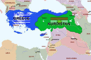
Kurdistan (Kurdish: Kurdistan/كوردستان,
literally meaning "the land of kurds"; formerly Curdia, Curdistan) is an extensive plateau and mountainous area in middle east, inhabited mainly by Kurds. It covers large parts of eastern Turkey, northern Iraq, northwestern Iran and smaller parts of northern Syria and Armenia. It roughly includes Zagros and eastern Taurus mountain ranges.
From a political standpoint, Iraqi Kurdistan is the only region which has
gained official recognition internationally as an autonomous federal entity.
History
Ancient period
Recognition of the existence of a Kurdish land goes back even as far as Sumerian Cuneiform Tablets,
dating from about 3000 BC, which speak of the land of the Kurds .
Much of Kurdistan corresponds roughly with the ancient Kingdom of Gutium (Qurti), which
is mentioned in cuneiform records about 2400 BC, and had its capital at Arraphkha (modern kirkuk).
The tract to this day known as Kurdistan, the high mountain region south and south-east of Lake Van between Persia and Mesopotamia, was in the possession of Kurds from before the time of Xenophon, and was known as the country of the Carduchi (Greek: Καρδούχοι),
as Cardyeneor Cordyene.
At their peak, the Romans ruled large Kurdish-inhabited areas, particularly the western
and northern Kurdish areas in the Middle East. Kingdoms like Corduene were vassal states of the Roman
Empire. From 189 BC to AD 384, the ancient kingdom of Corduene
ruled northern Mesopotamia. It was situated to the east of Tigranocerta (i.e., to the east and south of
present-day Diyarbakir in south-eastern Turkey). It became a vassal state of
the Roman Republic in 66 BC. It remained
allied with the Romans until AD 384.
Some of the ancient districts of Kurdistan and their corresponding modern names are listed below.
- corduene or Gordyene (Siirt, Bitlis and $irnak)
- Sophene (Diyarbakir)
- Zabdicene or Bezabde (Gozarto d'Qardu or Jazirat Ibn or Cizre)
- Basenia (Bayazid)
- Moxoene (Mu$)
- Nephercerta (Miyafarkin)
- Artemita (Van)
One of the earliest records of the phrase land of the Kurds is found in a Syriac
Christian document of late antiquity describing the stories of Christian saints of Middle East such
as the holy Abdisho. When the Sassanid Marzban asked Mar
Abdisho about his place of origin, he replied that according to his parents, they were originally from Hazza, a village
in Assyria. However they were later driven out of Hazza by pagans, and settled in
Tamanon, which according to holy Abdisho was in the land of the Kurds. This village lies just north of the modern
Iraqi-Turkey border. Also Hazza is located 12 km southwest of modern Irbil. In another passage in the same document, the region of Khabur is also identified as land of
the Kurds.
Medieval period
In the second half of the 10thcentury, Kurdistan was shared amongst five big Kurdish
principalities. In the North the shaddadid (951–1174) (in
parts of Armenia and Arran) and the Rawadid (955–1221) (in Tabriz and Maragheh), in the East
the Hasanwayhid (959–1015) and the Annazid
(990–1116) (in Hulwan, Kermanshah and
Khanaqin) and in the West the Marwanid (990–1096) of Diyarbakir.
Kurdistan in the Middle Ages was refered to a collection of semi-independent
or in some cases independent states called "emirates". It was nominally under indirect political or religious
influence of Khalifs or Shahs. A comprehensive history of these states and their relationship with their neighbors is given
in the famous textbook of "Sharafnama" written by Prince Sharaf al -Din Bitlisi in 1597.
The best-known Kurdish Emirates included Baban, Soran, Badinan
and Garmiyan in present-day Iraq; Bakran, Botan (or Bokhtan) and Badlis in Turkey, and Mukriyan and Ardalan in Iran.
Modern period
In the 16th century, the Kurdish-inhabited areas were split between Safavid Iran and the Ottoman Empire after prolonged wars. The first important division of Kurdistan occurred
in the aftermath of the Battle of Chaldiran in 1514. This division was formalized
in the Treaty of Zuhab in 1639. Before World War I, most
Kurds lived within the boundaries of the Ottoman Empire in the province of kurdistan. After the collapse of the Ottoman Empire, the Allies agreed and planned to create several
countries within its former boundaries. Originally Kurdistan, along with Armenia, was to be one of them,
according to the never-ratified Treaty of $evres. However, the reconquest of these areas by Kemal
Ataturk and other pressing issues caused the Allies to accept the renegotiated Treaty of Lausanne, accepting the border of the modern Republic of Turkey and leaving the Kurds without a self-ruled
region. Other Kurdish areas were assigned to the new British and French mandated states of Iraq and syria under both treaties.
The Kurdish delegation made a proposal at the San FranciscoPeace Conference in 1945, showing the geographical extent of Kurdistan as claimed by the Kurds. This proposal encompasses an area extending
from the Mediterranean shores near Adana to the shores of the Persian Gulf near Bushehr, and it includes the Lur inhabited areas of southern Zagros.
Since World War I, Kurdistan has been divided between several states, in each of which
Kurds are minorities. At the end of the First Gulf War, the Allies established a safe haven
in northern Iraq. Amid the withdrawal of Iraqi forces from three northern provinces, Iraqi Kurdistan emerged as an autonomous
entity inside Iraq, with its own local government and parliament in 1992.
People
In addition to Kurds who comprise the majority of the population of the region there are also communities
of Arab, Armenian, Assyrian, Azeri, Jewish, Ossetian, Persian, and Turkkic people traditionally scattered
throughout the region alongside Kurds. Most of its inhabitants being Muslim there are also significant numbers of various
other religious sects such as Yazidi, Zoroastrian, Yarsan, Alevi, Christian, Jewish, Sarayi, Bajwan
and Haqqa etc.
Geography
According to Encyclopædia Britannica, Kurdistan covers about 190,000 km², and its chief towns are Diyarbakır(Amed),
Bitlis (Bedlîs) and Van
(Wan) in Turkey, Mosul (Mûsil), Arbil (Hewlêr) and Kirkuk (Kerkûk)
in Iraq, and Kermanshah (Kirmanşan), Sanandaj (Sine) and Mahabad(Mehabad) inIran .[ According
to the Encyclopaedia of Islam , Kurdistan covers around 190,000 km²in Turkey, 125,000 km² in Iran, 65,000 km² in Iraq,
and 12,000 km²in Syria and the total area of Kurdistan is estimated at approximately 392,000 km². Others estimate as many
as 40 million Kurds live in Kurdistan, which covers an area as big as France . The Kurdistan Province in Iran and Iraqi Kurdistan are both included in the
usual definition of Kurdistan.
Iranian Kurdistan encompasses Kurdistan Province and greater parts of West Azarbaijan , Kermanshah
, Īlām provinces. Iraqi Kurdistan is divided into six governorates, three of which — and parts of others —
are under the control of Kurdistan Regional Government . Syrian Kurdistanis mostly located in present-day northeastern
Syria. This region covers the greater part of the province of Al Hasakah. The main cities in this region are Al-Qamishli (
Kurdish : Qamişlû) and Al Hasakah (Kurdish: Hesaka).
Another region with a significant Kurdish population is in the northern part of Syria. The Kurdish-inhabited northern and
northeastern parts of Syria in Kurdish is called Kurdistana Binxetê. (see Demographics of Syria and Syria in
the CIA World Factbook ). A large area of south eastern Turkey is also home to estimated 15 to 20 million
Kurds .
Forests
Kurdistan is a mountainous region with a cold climate and it receives enough annual precipitation to sustain
temperate forests and shrubs. Mountain chains are covered with pasture, and its valleys with forests. There are around 16
million hectares (160,000 km²) of forests in all parts of Kurdistan. Firs, other conifers, and oaks can be found in those
forests. Deciduous platanus, willow, and poplar trees are found near waters and river banks.
Mountains
Mountains, even to this day, have been important geographical and symbolic figures in Kurdish
life, so that there is a saying that "Kurds have no friends but the mountains". The Mount Judi is the most important mountain
in Kurdish folklore and along with Mount Ararat, as one of them is thought to be the final resting place of Noah's Ark. Other
important mountains of Kurdistan are Zagros Shingar, Qendil, Shaho, Gabar, etc.
Rivers
There are many rivers in Kurdistan that are at least as important, if not more important, than oil.
The plateaus and mountains of Kurdistan, which are characterized by heavy rainfall and in winter a heavy coat of snow, are
a water reservoir for the Near and Middle East. This is the source of the famous Tigris and Euphrates Rivers as well as numerous
other smaller rivers like the Khabur, Tharthar, Ceyhan, Araxes, Kura, Sefidrud, Karkha, and Hezil, the major tributaries of
which spring from the mountains of Kurdistan. Those rivers that are entirely or nearly entirely in Kurdistan are usually of
historical importance to the Kurds. Among these are the Murat (Arasān) and Buhtān rivers in northern and western
Kurdistan (in Turkey); the Peshkhābur, the Lesser and the Greater Zab, and the Sirwan/Diyala in central Kurdistan (in
Iraq); and the Jaghatu (Zarrinarud), the Tātā'u (Siminarud), the Zohāb (Zahāb), and the Gāmāsiyāb
in southern Kurdistan.
With their water, the Tigris and the Euphrates give life not only to the Mesopotamian plain and
the whole of Kurdistan but also to Iraq and Syria. These rivers, which flow down from heights of three to four thousand meters
above sea level, are also very significant for the production of energy. Iraq and Syria have built numerous dams across these
rivers and their tributaries. The most important ones are a series of dams that were built by Turkey as part of the GAP project
(Southeast Anatolia Project). The GAP project is still not complete, but it already supplies a significant proportion of Turkey's
electrical-energy needs. Due to the extraordinary archæological richness of the land, almost any dam built in Kurdistan drowns
a portion of Kurdish history.
Lakes
Kurdistan extends to Lake Urmia in Iran on the east and to semi-contiguous Kurdish-inhabited regions
to the west on the Mediterranean shore. The region includes Lake Van, the largest body of water in Turkey; in the entire Middle
East, the only larger lake is Lake Urmia -- but Lake Urmia is not nearly as deep, so Lake Van contains a much larger volume
of water. The Zarivar Lake west of Marivan, as well as Lake Dukan near the city of Sulaymaniyah, are significant tourist sites.
Underground resources
There are many oil and mineral resources in Kurdistan. KRG-controlled parts of Iraqi
Kurdistan only by itself is estimated to have around 45bn barrels of oil reserves making it sixth largest in the world, mostly
recently discovered. Extraction of these reserves is said to begin within the first three months of 2007. These are excluding
those of Kirkuk and Mosul, cities claimed by the KRG to be included in its territory, though in these two cities oil was extracted
predominantly by Iraq's former Baath regime.
As of July 2007 the Kurdish government is inviting foreign companies to invest
in 40 new oil sites, with the hope of increasing regional oil production over the next half decade by a factor of five, to
about 1 million barrels per day. Gas and associated gas reserves are in excess of 100 TCF. Other underground resources that
exist in significant quantities in the region include copper, iron, zinc and limestone which is used to produce cement. The
world's largest deposit of rock sulphur is located just southwest of Erbil (Hewlêr). Other important underground resources
include coal, gold, and marble.
Subdivisions
Iraqi Kurdistan
Main article: Iraqi Kurdistan
The Kurdistan Region was originally established in 1970
as the Kurdish Autonomous Region following the agreement of an Autonomy Accord between the government of Iraq and leaders
of the Iraqi Kurdish community. A Legislative Assembly was established in the city of Arbil with theoretical authority over
the Kurdish-populated governorates of Arbil, Dahuk and As Sulaymaniyah. In practice, however, the assembly created in 1970
was under the control of Iraqi President Saddam Hussein until the 1991 uprising against his rule following the end of the
Persian Gulf War. Concerns for Safety of Kurdish refugees was reflected in the United Nations Security Council Resolution
688 which gave birth to a safe haven, in which allied air power protected a Kurdish zone inside Iraq. While the no-fly zone
covered Dohuk and Irbil, it left out Sulaimaniya and Kirkuk. Then following several bloody clashes between Iraqi forces and
Kurdish troops, an uneasy and shaky balance of power was reached, and the Iraqi government withdrew its military and other
personnel from the region in October 1991. At the same time, Iraq imposed an economic blockade over the region, reducing its
oil and food supplies. The region thus gained de facto independence, being ruled by the two principal Kurdish parties –
the Kurdish Democratic Party and the Patriotic Union of Kurdistan – outside the control of Baghdad. The region has its
own flag and National Anthem.
Elections held in June 1992 produced an inconclusive outcome, with the assembly divided almost
equally between the two main parties and their allies. During this period, the Kurds were subjected to a double embargo: one
imposed by the United Nations on Iraq and one imposed by Saddam Hussein on their region. The severe economic hardships caused
by the embargoes fueled tensions between the two dominant political parties: KDP and PUK over control of trade routes and
resources. This led to internecine and intra-Kurdish conflict and warfare between 1994 and 1996. After 1996, 13% of the Iraqi
oil sales were allocated for Iraqi Kurdistan and this led to a relative prosperity in the region. Direct United States mediation,
led the two parties to a formal ceasefire in Washington Agreement in September 1998. It is also argued that the Oil for Food
Program from 1997 onward had an important effect on cessation of hostilities. Kurdish parties joined forces against the Iraqi
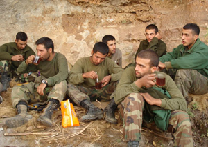
government in the Operation Iraqi Freedom in Spring 2003. The Kurdish military forces known as peshmerga played a key role
in the overthrow of the former Iraqi government.
KDP and PUK have united to form an alliance with several smaller parties,
and the Kurdish alliance has 53 deputies in the new Baghdad parliament, while the Kurdish Islamic Union has 5. PUK-leader
Jalal Talabani has been elected President of the new Iraqi administration, while KDP leader Massoud Barzani is President of
the Kurdistan Regional Government.
Iranian Kurdistan
Main article: Iranian Kurdistan
Syrian Kurdistan
Main article: Kurds in Syria
Turkish Kurdistan
Main article: Turkish Kurdistan
Turkish Kurdistan (Turkish: Türkiye Kürdistanı
or Kuzey Kürdistan ("Northern Kurdistan") or Kuzeybatı Kürdistan ("Northwestern Kurdistan"), Kurdish: Kurdistana
Tirkiyê or Bakurê Kurdistanê ("North of Kurdistan")) is an unofficial name for the southeastern part of Turkey,
densely inhabited by Kurds. As the 1965 census, which is the last Turkish census with the language question, shows that 7.07%
of Turkish citizens speak Kurdish; the total Kurdish population of the area is estimated to be 3 million, of the total population
of 6,608,619.The area covers about 230,000 km² (88,780 sq mi), or nearly a third of Turkey. It forms part of the wider Kurdish-inhabited
region known as Kurdistan, which encompasses parts of Turkey, Syria, Iran and Iraq.
The Encyclopaedia of Islam describes
Turkish Kurdistan as covering at least 17 provinces of Turkey: Erzincan, Erzurum, Kars, Malatya, Tunceli, Elazığ,
Bingöl, Muş, Ağrı, Adıyaman, Diyarbakır, Siirt, Bitlis, Van, Şanlıurfa aka Urfa, Mardin
and Hakkâri, stressing at the same time that "the imprecise limits of the frontiers of Kurdistan hardly allow an exact appreciation
of the area." [4]. Since 1987, four new provinces - Şırnak, Batman, Iğdır and Ardahan - have been created
inside the Turkish administrative system out of the territory of some of these provinces. The region has no unified administrative
identity and the Turkish state rejects the use of the term "Kurdistan" to describe it. In addition to the provinces already
mentioned, the region forms part of the wider geographic subdivisions of Southeastern Anatolia Region (Güneydoğu Anadolu
Bölgesi) and Eastern Anatolia Region (Doğu Anadolu Bölgesi).
The region forms the south-eastern edge of Anatolia.
It is dominated by high peaks rising to over 3,700m (12,000 ft) and arid mountain plateaux, forming part of the arc of the
Taurus Mountains. It has an extreme continental climate — hot in the summer, bitterly cold in the winter. Despite this,
much of the region is fertile and has traditionally exported grain and livestock to the cities in the plains. The local economy
is dominated by animal husbandry and small-scale agriculture, with cross-border smuggling (especially of petroleum) providing
a major source of income in the border areas. Larger-scale agriculture and industrial activities dominate the economic life
of the lower-lying region around Diyarbakır, the largest Kurdish-populated city in the region. Elsewhere, however, decades
of conflict and high unemployment has led to extensive migration from the region to other parts of Turkey and abroad.
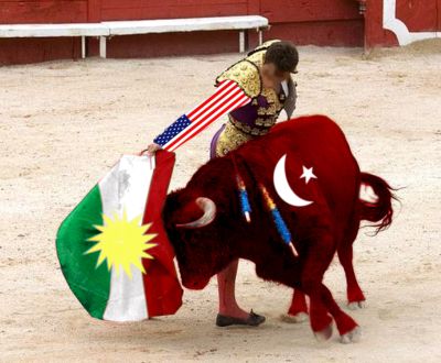
Conflict and controversy
Main article: Kurds in Turkey
The incorporation into Turkey of the Kurdish-inhabited
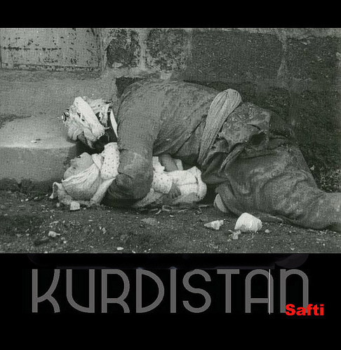
regions of eastern Anatolia was opposed by many Kurds, and has resulted in a long-running separatist conflict in which thousands
of lives have been lost. The region saw several major Kurdish rebellions including; the Koçkiri Rebellion of 1920, the Sheikh
Said Rebellion in 1924, the Republic of Ararat in 1927, and the Dersim Rebellion in 1937. These were forcefully put down by
the Turkish authorities and the region was declared a closed military area from which foreigners were banned between 1925
and 1965.
In 1983, the Kurdish provinces were placed under martial law in response to the activities of the militant separarist
Kurdistan Workers Party (PKK). An extremely violent guerrilla war took place through the rest of the 1980s and into the 1990s,
in which much of the countryside was evacuated, thousands of Kurdish-populated villages were destroyed and numerous extrajudicial
summary executions were carried out by both sides. More than 37,000 people were killed in the violence and hundreds of thousands
more were forced to leave their homes. The situation in the region has since eased following the capture of the PKK leader
Abdullah Öcalan in 1999 and the introduction of a greater degree of official tolerance for Kurdish cultural activities, encouraged
by the European Union. However, some political violence is still ongoing and the Turkish-Iraqi border region remains tense.
Climate
The region has an extreme continental climate — hot in the summer, bitterly cold in the winter.
Despite this, much of the region is fertile and has traditionally exported grain and livestock to the cities in the plains.
The local economy is dominated by animal husbandry and small-scale agriculture, with cross-border smuggling (especially of
petroleum) providing a major source of income in the border areas. Larger-scale agriculture and industrial activities dominate
the economic life of the lower-lying region around Diyarbakir, the largest Kurdish-populated city in the region. Elsewhere,
however, decades of conflict and high unemployment has led to extensive migration from the region to other parts of Turkey
and abroad.
There are many rivers flowing and running through mountains of Kurdistan making it distinguished by its fertile
lands, plentiful water, and picturesque nature. The mountainous nature of Kurdistan, the difference of temperatures in its
various parts, and its wealth of waters, make Kurdistan a land of agriculture and tourism. Because of its high altitude, the
climate of Kurdistan is harsh. There is a lot of snowfall in the high mountains. Precipitation varies between 200 and 400
mm a year in the plains, and between 700 and 3,000 mm a year on the high plateaux between mountain chains.